View online
Prévisible (prédictable)
Generative and interactive audiovisual installation
online et offline
Antoine Schmitt 2019
Production: M-topia
Support: DICREAM, Région Provence-Alpes-Côte d’Azur (FR)
Creation realized within the production platform Chroniques, supported by Seconde Nature and ZINC
Project intiated and designed by M-topia / Fanny Bordier within hétérotopies#2
Artwork design, creation : Antoine Schmitt in partnership with GeographR / Philippe Rossello
Collaboration for sound sources: Jeroen Strijbos & Rob Van Rijswijk and the “Université de Lorraine, sous-direction des usages du numérique production audiovisuelle et multimédia (FR)”
The Prévisible (prédictable) project uses the European regional climate model simulations, extracted within the framework of a study directed by the research center GeographR dealing with the evolution of climate on the Grand site Sainte-Victoire territory (east of Aix en Provence, France). Standing in the perspective of the future climate, Prévisible aims at questioning the notions of predictability and responsibility in complex realities.
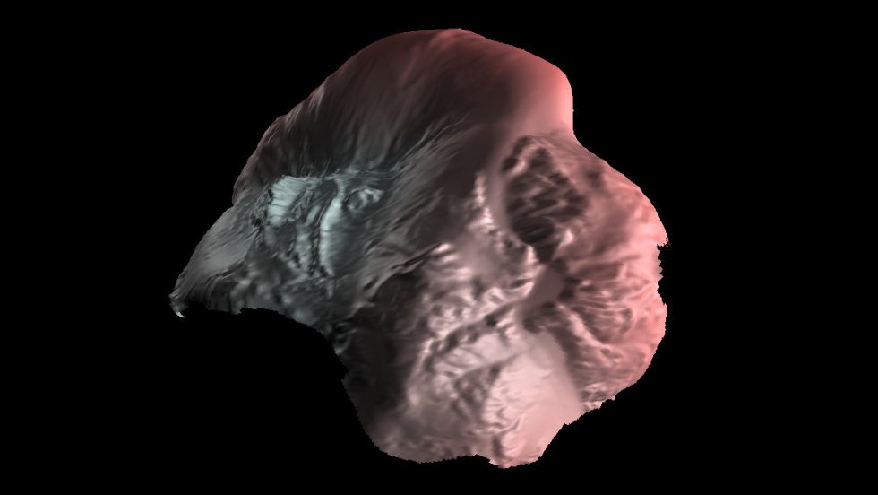
At the beginning, a 3D map of the Grand Site Sainte-Victoire territory lies before you.
When you activate the “Start Time” button, time passes from 2020 to 2100 at high speed and generates a projection, a possible scenario of the years to come based on a combination of climate variables (temperatures and precipitations) and regional climate models. Then, it slows down and rewinds back. At each activation, a new projection is drawn, and this indefinitely. This choice of “starting time”, minimal action of the spectator, determines the future path. All these probable futures are based on climate projections of the Euro_Cordex european climate models according to various socio-economic scenarios (RCP) on a time frame of 80 years.
Prévisible stages an imaginary object : a living map. This map is an organism gifted with a body sensitive to temperature and precipitations to which it reacts by mutating, over time, into a pulsating sphere. This transformation, generated by physical and organic simulation algorithms, delves the spectator into an abstract fiction, the life of a strange and tormented creature.
Thus, the geographical sectors of the map inflate and become red if the maximal daily temperature is higher than the one of the reference year 2020, and they deflate and become blue if the daily precipitations are higher than 2020. There are therefore interactions between maximal temperatures and precipitations, which result from mutual amplification or neutralization phenomenons. For example, high maximal temperatures associated with a drought create intense effects just like these same conjunctions in the real world.
Because of the temporal inertia inherent to this simulated body, the effects have a tendency to accumulate over time, like in the real world, leading to critical or dramatic situations : high temperature on a long period, lack of precipitations, episodes of intense rain…
The global rise of maximal temperature and the evolution of precipitations relatively to the reference period create multiple tensions inside the sensitive body (the living map) which are expressed through audio emissions which loudness and pitch reflect the amplitude and nature of these tensions. High maximal temperatures push for example the sound in high pitches.


Comments are closed.